
Tallahassee, Florida Stadtkarten-Kunst-Druck | RedKalion
Tallahassee, Florida Stadtkarten-Kunst-Druck | RedKalion
Verfügbarkeit für Abholungen konnte nicht geladen werden
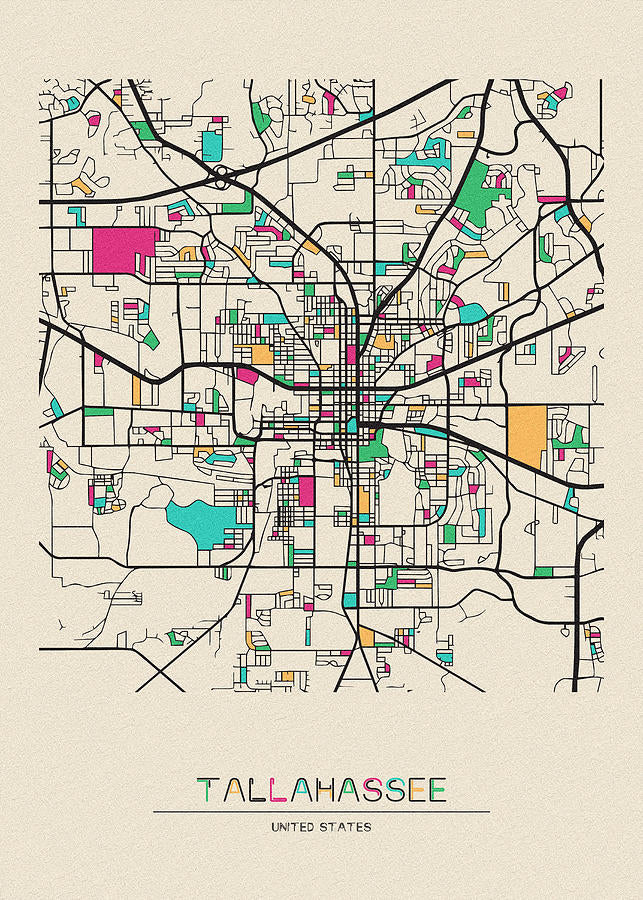
Dieses Stadtplan-Kunstwerk von Tallahassee, Florida, fängt die städtische Struktur der Hauptstadt Floridas mit einer Mischung aus kartografischer Präzision und künstlerischem Flair ein. Als detaillierte Darstellung hebt es wichtige Wahrzeichen, Straßen und natürliche Merkmale hervor und bietet eine visuelle Erzählung über die Entwicklung und den geografischen Charakter der Stadt. Ideal zur Dekoration oder für Bildungszwecke, dient es als zeitloses Stück, das Betrachter mit der einzigartigen Identität Tallahassees verbindet.
Historischer Kontext des Tallahassee-Stadtplans
Tallahassee, gegründet 1824, wurde zur Hauptstadt Floridas aufgrund seiner zentralen Lage zwischen den ehemaligen Hauptstädten St. Augustine und Pensacola. Dieser Stadtplan von Tallahassee, Florida, spiegelt das Wachstum von einer kleinen Siedlung zu einem modernen Zentrum wider und integriert Elemente wie den Kapitolkomplex, die Florida State University und den Lake Ella. Das Design greift oft auf historische Vermessungen und moderne GIS-Daten zurück, verbindet alten Charme mit zeitgenössischer Genauigkeit, um die Entwicklung der Stadt im Laufe der Zeit darzustellen.
Stilistische Analyse dieses Stadtplan-Kunstwerks
Stilistisch setzt dieser Tallahassee-Stadtplan auf klare Linien, dezente Farbpaletten und hierarchische Beschriftungen, um die Lesbarkeit zu verbessern und gleichzeitig ästhetischen Reiz zu bewahren. Techniken wie Schummerung oder illustrative Symbole können verwendet werden, um Parks, Gewässer und Stadtzonen zu kennzeichnen und so eine ausgewogene Komposition zu schaffen, die sowohl informativ als auch visuell ansprechend ist. Die Anordnung des Plans priorisiert Klarheit und macht ihn sowohl für Gelegenheitsbetrachter als auch für Kartografie-Enthusiasten zugänglich.
Druckspezifikationen & Materialien
- Verfügbare Größen: 75×100 cm / 30×40″, 40×50 cm / 16×20″, 21×29,7 cm / 8×12″
- Papierfinish: Matt, unbeschichtet, natürliches Weiß (cremeweiß)
- Säurefrei: pH-Wert über 7, um Vergilben mit der Zeit zu verhindern
- Papiergewicht: 250 g/m² (110 lb) | Dicke: 0,29 mm (11,4 mils)
- Nachhaltiges Papier: FSC-zertifiziert
Dieser Stadtplan-Kunstwerk von Tallahassee, Florida, von RedKalion vereint handwerkliche Expertise mit archivbeständigen Materialien und stellt so sicher, dass es ein langlebiges und elegantes Stück für jeden Raum bleibt. Vertrauen Sie auf unsere museumswürdigen Standards für ein Werk, das Tallahassees Vermächtnis in jedem Detail ehrt.
```
Discover Unlimited Art Possibilities
At RedKalion, you can find virtually any artwork from any artist, available in a wide range of sizes to perfectly match your space.
If you didn’t find what you’re looking for, contact us at support@redkalion.com . We will source any artwork and produce it in any size and format you need, including art prints, posters, canvas, framed pieces, framed canvas, and more.
For dedicated art enthusiasts, we also offer handcrafted replicas of any artwork, carefully painted by highly skilled artists using traditional techniques.
For custom requests, contact us at support@redkalion.com .
What landmarks are featured on this Tallahassee, Florida city map?
This map includes key landmarks such as the Florida State Capitol, Florida State University, Lake Ella, and major parks, providing a comprehensive view of Tallahassee's urban layout and natural features for accurate navigation and decor.
What type of paper is used for this city map art print?
We use FSC-certified, acid-free paper with a matte finish and 250 gsm weight to ensure durability and prevent yellowing, making this Tallahassee city map a long-lasting archival-quality print for home or office display.
How is this Tallahassee city map shipped and packaged?
Our prints are shipped in sturdy, flat packaging with protective layers to prevent damage during transit, ensuring your city map of Tallahassee, Florida arrives in perfect condition for framing and display.
How long will this art print last without fading?
With acid-free paper and high-quality inks, this Tallahassee city map art print is designed to resist fading for decades under normal indoor lighting conditions, maintaining its vibrant colors and details over time.
Can I customize the size of this Tallahassee, Florida map print?
Yes, this city map is available in three standard sizes: 75×100 cm, 40×50 cm, and 21×29.7 cm, allowing you to choose the best fit for your space without compromising on the detailed cartographic quality.
What historical sources inform this Tallahassee city map design?
This map draws from historical surveys, archival maps, and modern geographic data to accurately depict Tallahassee's evolution, blending traditional cartographic techniques with contemporary accuracy for an authentic representation.
How does this map highlight Tallahassee's geographic features?
It uses shaded relief and illustrative elements to emphasize natural features like lakes, hills, and green spaces, providing a nuanced view of Tallahassee's terrain alongside its urban infrastructure for enhanced visual appeal.