
Petaluma City Map Art Print | Premium-Kartografische Wandkunst | RedKalion
Petaluma City Map Art Print | Premium-Kartografische Wandkunst | RedKalion
Verfügbarkeit für Abholungen konnte nicht geladen werden
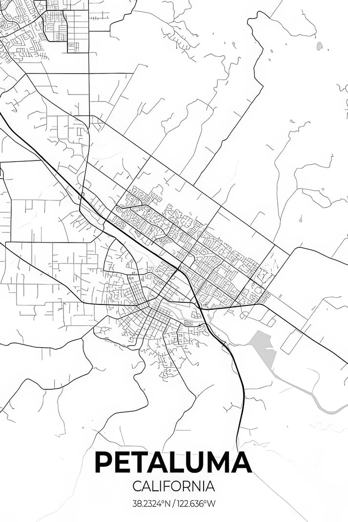
Dieses Stadtplan-Kunstwerk von Petaluma fängt das historische Layout von Petaluma, Kalifornien, mit Fokus auf seinen Ursprüngen im 19. Jahrhundert und der Flusslandschaft ein. Erstellt im Stil einer detaillierten Kartographie, hebt es wichtige Wahrzeichen wie den Petaluma River und das Downtown-Gitter hervor und bietet eine Mischung aus navigatorischer Klarheit und ästhetischem Reiz für Dekoration oder Bildungszwecke.
Historischer Kontext des Petaluma-Stadtplans
Petaluma, gegründet in den 1850er Jahren während des kalifornischen Goldrausches, entwickelte sich zu einem landwirtschaftlichen und Mühlenzentrum. Dieser Plan spiegelt die frühe Stadtplanung wider, beeinflusst durch die Rolle des Petaluma River als Transportweg. Das Design integriert vintage Elemente und veranschaulicht die Entwicklung der Stadt von einem Handelsposten zu einer modernen Gemeinschaft.
Stilistische Analyse dieses kartographischen Drucks
Mit Präzision umgesetzt, verwendet dieser Stadtplan von Petaluma gedämpfte Töne und klare Linien, um Topographie und Straßennetzwerke hervorzuheben. Er verzichtet auf überladene Verzierungen und setzt stattdessen auf Lesbarkeit, während ein klassisches, archivtaugliches Erscheinungsbild bewahrt wird – ideal zum Rahmen für Zuhause oder Büro.
Druckspezifikationen & Materialien
- Verfügbare Größen: 75×100 cm / 30×40″, 40×50 cm / 16×20″, 21×29,7 cm / 8×12″
- Papierfinish: Matt, ungestrichen, natürliches Weiß (cremeweiß)
- Säurefrei: pH-Wert über 7 zur Vermeidung von Vergilbung im Laufe der Zeit
- Papiergewicht: 250 g/m² (110 lb) | Dicke: 0,29 mm (11,4 mils)
- Nachhaltiges Papier: FSC-zertifiziert
Bei RedKalion spezialisieren wir uns auf museumstaugliche Reproduktionen und stellen sicher, dass dieser Stadtplan-Kunstdruck von Petaluma archivtauglichen Standards für eine langlebige Präsentation entspricht. Vertrauen Sie auf unsere Expertise für authentische, detaillierte kartographische Kunst, die jeden Raum bereichert.
```
Discover Unlimited Art Possibilities
At RedKalion, you can find virtually any artwork from any artist, available in a wide range of sizes to perfectly match your space.
If you didn’t find what you’re looking for, contact us at support@redkalion.com . We will source any artwork and produce it in any size and format you need, including art prints, posters, canvas, framed pieces, framed canvas, and more.
For dedicated art enthusiasts, we also offer handcrafted replicas of any artwork, carefully painted by highly skilled artists using traditional techniques.
For custom requests, contact us at support@redkalion.com .
What historical details does this Petaluma city map include?
This map highlights Petaluma's 19th-century layout, featuring the Petaluma River, downtown streets, and early landmarks, reflecting its growth from a Gold Rush-era settlement.
What paper is used for this fine art print?
We use FSC-certified, acid-free paper with a matte finish, 250 gsm weight, and natural white color to ensure durability and prevent yellowing over time.
How is this Petaluma map art print shipped?
Prints are carefully rolled in protective tubes and shipped via tracked courier, with delivery times varying by location for safe arrival.
Is this print archival and long-lasting?
Yes, it's made with acid-free, pH-balanced materials and sustainable paper to resist fading and degradation, ensuring decades of display.
Can I customize the size of this city map print?
This Petaluma city map is available in three standard sizes: 75×100 cm, 40×50 cm, and 21×29.7 cm, optimized for framing and wall decor.
What makes this map stylistically unique?
It combines vintage cartographic techniques with modern clarity, using muted colors and precise lines to emphasize Petaluma's geographic and historical features.
How does this map reflect Petaluma's development?
The design shows the city's grid pattern and river integration, illustrating its evolution from a 1850s trading post to a structured urban area.