
Grand Rapids City Map Art Print | Premium Kartographie | RedKalion
Grand Rapids City Map Art Print | Premium Kartographie | RedKalion
Verfügbarkeit für Abholungen konnte nicht geladen werden
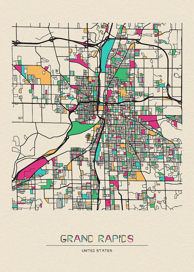
Dieses Stadtplan-Kunstwerk von Grand Rapids fängt das städtische Layout von Michigans zweitgrößter Stadt mit der Präzision historischer Kartographie und der ästhetischen Anziehungskraft feiner Kunst ein. Erstellt Ende des 19. oder Anfang des 20. Jahrhunderts, spiegelt die Karte das Wachstum von Grand Rapids während seiner industriellen Blütezeit wider, als es zu einem wichtigen Zentrum für Möbelherstellung und Flusshandel entlang des Grand River wurde.
Historischer Kontext des Stadtplans von Grand Rapids
Der Plan stammt wahrscheinlich aus der Zeit zwischen 1880 und 1920, einer Phase rascher Expansion für Grand Rapids. Er zeigt wichtige Wahrzeichen wie den Grand River, das Straßennetz der Stadt und frühe Industrieviertel. In dieser Ära wandelte sich die Stadt von einer kleinen Siedlung zu einer pulsierenden Metropole, wobei Kartographen ihre sich entwickelnde Infrastruktur akribisch dokumentierten.
Stilistische Analyse dieses Stadtplans von Grand Rapids
Stilistisch bedient sich der Plan eines klassischen kartographischen Ansatzes mit klarer Typographie, detaillierten Straßennetzen und dezenten Farbverläufen zur Kennzeichnung verschiedener Zonen. Das Design vereint Funktionalität mit Kunstfertigkeit und nutzt gravierten Linien und handkolorierte Elemente, die für die vor-digitale Kartenerstellung typisch waren. Dadurch ist er nicht nur ein Navigationswerkzeug, sondern auch ein visuelles Zeugnis der Stadtplanung und Architekturgeschichte.
<2>Druckspezifikationen & Materialien- Verfügbare Größen: 75×100 cm / 30×40″, 40×50 cm / 16×20″, 21×29.7 cm / 8×12″
- Papierfinish: Matt, ungestrichen, natürliches Weiß (cremeweiß)
- Säurefrei: pH-Wert über 7 zur Vermeidung von Vergilben mit der Zeit
- Papiergewicht: 250 g/m² (110 lb) | Dicke: 0,29 mm (11,4 mils)
- Nachhaltiges Papier: FSC-zertifiziert
Bei RedKalion spezialisieren wir uns auf museumswürdige Reproduktionen, die das ursprüngliche Handwerk von Karten wie diesem Stadtplan von Grand Rapids ehren. Unsere Drucke sind ideal für Historiker, Dekorateure und alle, die über bleibende Kunst eine Verbindung zum reichen städtischen Erbe Michigans herstellen möchten.
```
Discover Unlimited Art Possibilities
At RedKalion, you can find virtually any artwork from any artist, available in a wide range of sizes to perfectly match your space.
If you didn’t find what you’re looking for, contact us at support@redkalion.com . We will source any artwork and produce it in any size and format you need, including art prints, posters, canvas, framed pieces, framed canvas, and more.
For dedicated art enthusiasts, we also offer handcrafted replicas of any artwork, carefully painted by highly skilled artists using traditional techniques.
For custom requests, contact us at support@redkalion.com .
What time period does this Grand Rapids city map represent?
This map depicts Grand Rapids, Michigan, likely from the late 19th to early 20th century, showing its growth during the industrial era with detailed street layouts and key landmarks.
What are the available sizes for this city of Grand Rapids map art print?
This fine art print is available in 75×100 cm (30×40″), 40×50 cm (16×20″), and 21×29.7 cm (8×12″) sizes, suitable for various display needs from large wall art to smaller accents.
Is the paper used for this print archival quality?
Yes, our prints use acid-free, FSC-certified paper with a pH above 7 to ensure longevity and prevent yellowing, making them a durable choice for preserving this Grand Rapids map art.
How is this Grand Rapids city map art print shipped?
We ship prints in sturdy, flat packaging to prevent damage, with options for domestic and international delivery to ensure your city of Grand Rapids map arrives safely.
Can this map print be framed easily?
Yes, the standard sizes and matte finish make framing straightforward; we recommend using acid-free mats and UV-protective glass for best archival display of this Grand Rapids art print.
What landmarks are featured on this historical Grand Rapids map?
The map includes the Grand River, major streets, and early industrial districts, highlighting the city's layout during its peak as a furniture manufacturing hub in Michigan.
How was this city of Grand Rapids map originally created?
It was likely produced using engraved plates and hand-coloring techniques common in 19th-century cartography, offering a detailed and artistic view of urban development.